
The big excitement in Chillicothe Tuesday evening was a structure fire on the edge of Yoctangee Park. 
As reported by the Chillicothe Gazette and Clear Channel Radio, it was called in at 7:16 pm, and ended up a total loss. Clear Channel received a good photo of the full blaze on 26 May 2014.
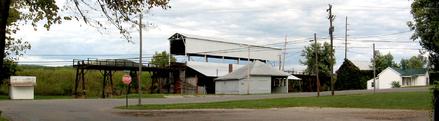
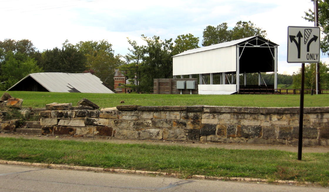
I was inside the Majestic Theatre at the time and hear the sirens, but had no idea why they were sounding. The landmark there at about 199 North Mulberry Street that everyone thinks of, the fireproof “coal tipple,” did not burn. What burned was an adjunct wooden building that was a part of the coal yard complex.
The Gazette labels the barn-like building as “historic,” but that’s an overstatement. “Historical” means old; “historic” means old and significant.
It was just a utilitarian structure that communicated part of the historic industrial activity there, and was not anything critical to city history. Still, it is a loss…though the way it was being neglected, it was going to be a loss soon.
I’ve heard the city has recently been in communication with the owner, Litter Petroleum, to acquire the tract and presumably expand the park into that corner. I figured that process would end up with the loss of some or all of the structures…but flames have made that a little easier.
IA
One of my interests in architecture and history is “Industrial Archaeology” – not digging up old factories, but understanding and exploring industrial structures and processes in general, such as grain elevators, breweries, pump houses, etc.
This complex in the excluded corner of Yoctangee Park has interested me for a while, and I featured it in my “Yoctangee Park Industry Tour” (which I plan to reprise soon).

I love aerial photos. I also love county auditor websites that provide an amazing resource of aerial photos (from multiple years!).
Built on the Bed
The land the facility stands on used to not be land…at least reliable land.
When Chillicothe was platted in the wilderness of 1796, the Scioto River flowed through this location. The center of what is now the park was an “island,” and Water Street had a dock at Paint Street. (A good visual of that is the HO-gage model of Water Street in 1811 in the Ross County Heritage Center.)
However shippable, the river bed that is now part of the park lake may have been a secondary channel for the Scioto, because in a flood in 1817 the Scioto rerouted itself into the northern channel and left the Water Street channel unusable.* After failed attempts to reroute the rerouted river, the flood slough and floodplain became a de facto town dump.
When the Marietta & Cincinnati Railroad built its fill across the floodplain in 1851,* the situation became worse, with flood seepage now diked in among the refuse. About that time it also received raw sewage from a downtown hotel. Riders on the new railroad were warned to douse themselves with quinine as they passed the location.
But in the 1870s, the town fathers finally made a silk purse out of a sow’s ear: “City Park” was developed out of the wasteland, later renamed Yoctangee in 1903.*
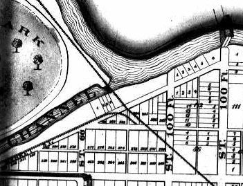
Right about that time, Gould’s 1875 atlas shows only a few lots platted on the north side of Riverside Street, and apparently nothing north of the old channel – or in it. The partly developed park is shown as a generic schematic. There’s still an outlet for the old channel under the railroad, where the tipple will be built; Mulberry Street ends at Riverside, which is still named Market Street.
Post-Park

The 1889 bird’s eye view of Chillicothe shows the park fully developed, with smoky industries along the canal and railroad. (Smokestacks were progress to the Victorians!)
By this time, the old river slough has been filled in east of Mulberry Street, and a coal tipple is there (though not the current one). A small house is also in front of it, facing Mulberry Street, and a couple buildings are behind that. The highbank is not visible in this artistic depiction. (Hear more about this image in my “Yoctangee Park Industry Tour” (which, again, I plan to reprise).
Preserved by Fire…Fire Maps, That Is

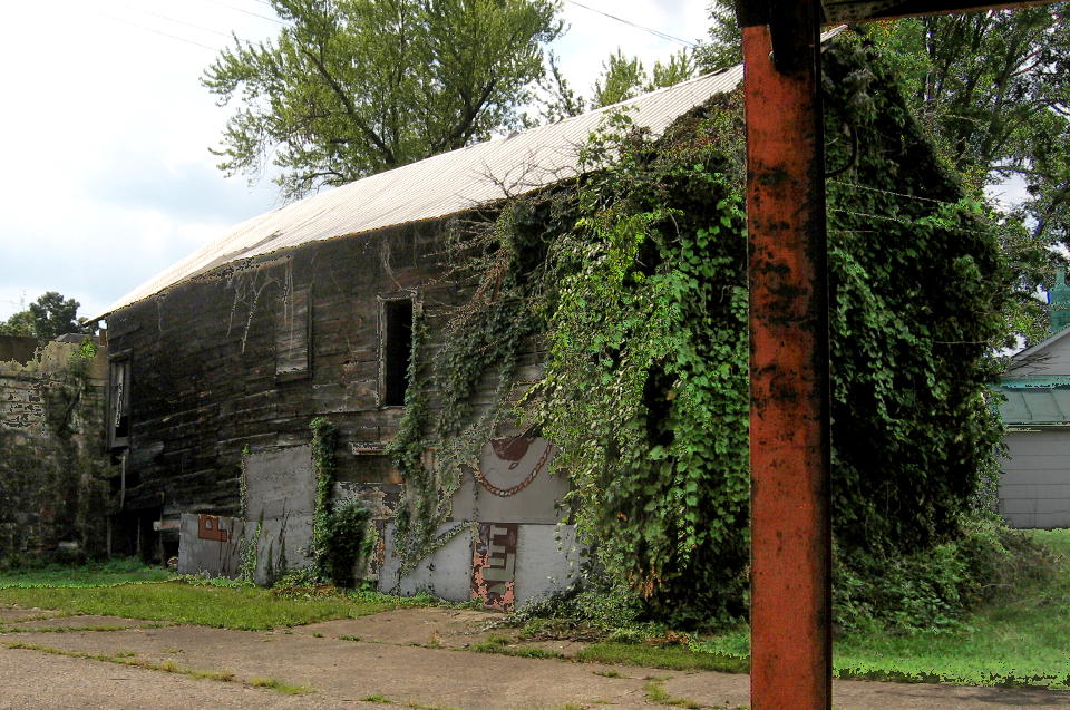
This is an excerpt from the earliest fire insurance map** that shows the site, dating to August of 1900. It shows the coal tipple, owned (and probably built) by the railroad. The small two-room house is in front of the facility, and I suspect it became part of the house there now (with melted siding).
But along the bank, apparently paralleling it, is a two-story “ice house” with additions and / or extensions. The alignment is not exact, but I believe this shows that the burned building was there by 1900. I’d say the back buildings shown in 1889 are part of what is shown here.
By the next, February 1909, fire insurance map, the current tipple appears to have replaced the old – a new fireproof, steel-frame, bridge-like structure. (An Ohio Historical Inventory form dates the tipple to 1928, however, but the contemporaneous 1909 map is probably more trustworthy for the date.)
The last fire insurance map I have, from 1945, shows the facility pretty much as it is now. (Well, before Tuesday evening.) The ice house is now a warehouse, shorn of its extensions. The house has been enlarged, with additions probably to the west and north. 
A Civil War Hero’s Company
The coal facility is one of the few remaining reminders of the industrial area along the former river bank and railroad around Riverside Street. Two grain elevators and a brewery on Water east of Paint are now gone. At the northeast corner of Riverside and Mulberry, remnants of a tannery are now part of the school bus facility. An old brick warehouse still stands behind the flatiron building at Riverside and Race. The sites of two pork packing plants along the river that used the waterway as an open sewer, on either side of Hickory, are under the floodwall. The coal tipple remains. For now.
In asking me for some history of the burned building, Gazette reporter Jona Ison mentioned that the property was bought by Litter Petroleum in 1962 from the Union Coal Company.
The Union Coal Company was founded by Richard Enderlin, a Civil War hero, philanthropist, and prosperous businessman who tended to name his companies after the Union. Enderlin was born in Germany and immigrated to Huntington Township with his family about 1854 (I’m betting near Jester / Chester Hill Road, an area of German settlement).
He volunteered for the Civil War as a drummer boy, soon became a private, heroically rescued a dying comrade from no-man’s-land in the battle of Gettysburg, and earned a Congressional Medal of Honor for that. (Hear any of my tours that go past his monument at the entry to Yoctangee Park for a fuller version of the story.)
After the war, the formerly hungry and poor country boy moved into town, got himself educated in business classes, and started a prominent career. By the early 1870s he became manager of the Petrea Coal Company which was reorganized in 1875 as the Union Coal Company, Enderlin’s first business. Eventually it became the Union Coal & Ice Company.***
The company had several facilities in town, most alongside a railroad or two: a lumber yard complex at 109 North Bridge Street; an ice warehouse in the center of the block bounded by East Main, East Second, North Sugar streets, and Mosher Alley; I believe the original Petrea coal tipple at the intersection of the N&W and CH&D railroads; and a little coal office where deliveries could be ordered at about 4 East Second…and of course, the coal tipple at the east corner of City Park.
Photorecordation
I was hoping to get permission for a tour inside the ramshackle building. It’s too late for that, but at least I have some decent photos, all taken in the summer of 2012:
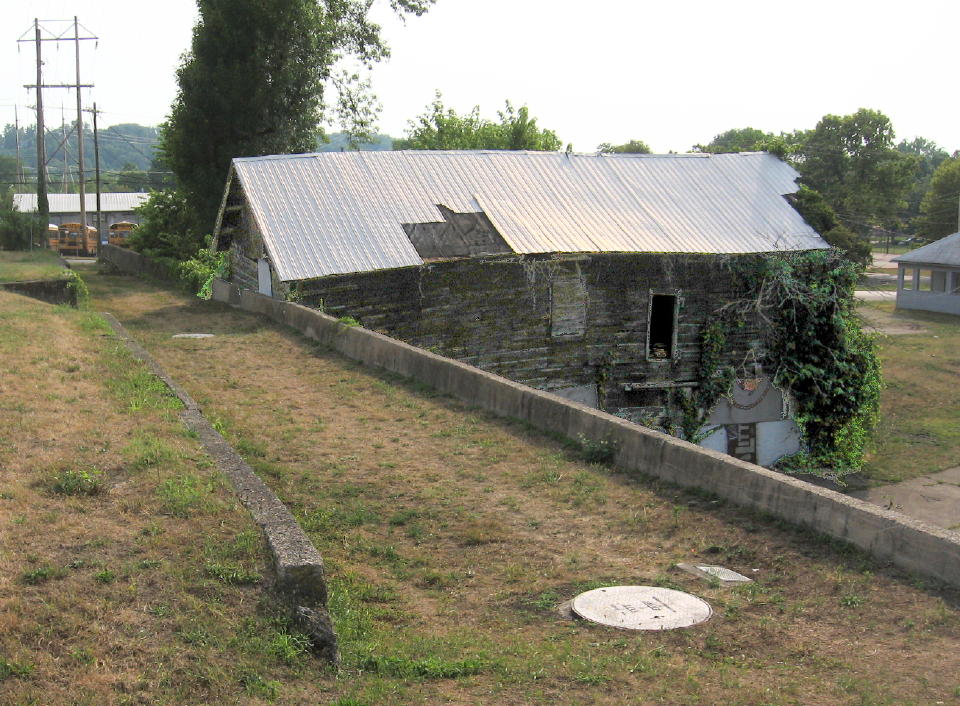
The alley is denoted in the 1945 fire insurance map. The large disc in the foreground, like a manhole cover, is “relief well,” probably to relieve water pressure from the highbank during extreme floods. It probably dates to construction of the floodwall about 1970.
The stone wall along the sidewalk reminds us of the old workers cottages lost here, small modest homes for day laborers in the nearby industries.
The street sign reminds us of the railroad spur in the median that extended to the lost industries along Water Street: Standard Cereal (the site of Kitchen Collection), Knecht and later Wagner brewery (the bank and pizza place), Standard Elevator (parking lot and monument park)…and the track between Water Street and the park that is is now the location of the cabooses.
Burned Bones of an Abandoned Barn
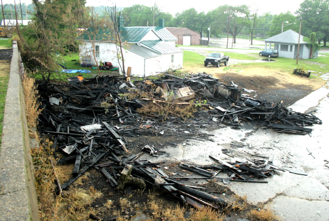
There is no speculation of the cause of the fire in these first news stories, but I’m betting arson is suspected. I won’t bet on whether it can be proven. And if you think enough evidence will be found so that an arsonist will be arrested for this, I have a bridge to sell ya.
Again, I am forced to make an offer: a free tour for anyone who can help bring any local arsonist to justice.
I will not ask what you did to the arsonist.
I welcome any corrections, comments, and additions to my compositions – especially additional historical information. * Read more in Pat Medert’s 1998 book Stories from Chillicothe’s Past. Her Gazette column “From River to City Park” is on pages 57-58.
** The online network of Ohio libraries, OhioLINK, has an extensive holding of these Sanborn Fire Insurance maps, accessible (and downloadable!) through its website. I have done so for all of the eight editions for Chillicothe from 1884 through 1945 – ask me for copies. However, OhioLINK’s copies are black-and-white microfilm and lack the color coding for building materials. For some reason they don’t have the 1879 issue, for which I must consult an original at the Ross County Historical Society.
*** Read more in Pat Medert’s 2009 book Water Street – Chillicothe, Ohio – Its Buildings and People. The entry for Enderlin is footnote 99, on pages 178-179.
Kevin B. Coleman is Intrepid Heritage Services – a pre/historic tour guide, speaker, presenter, researcher, writer, architectural historian, preservationist, and historical interpreter.

Thank you for all the information, photos, and maps. I like the way you “round out” the story by going beyond “just the facts, ma’am.” Also, I never realized there was a difference between “historic” and “historical”! I appreciate the time you’ve taken to research, document, and decipher Chillicothe’s history; as a native Chillicothean, I’ve often wanted to know “the rest of the story”. Now that I’ve used quotations too often in just a couple sentences, but not more often than I’ve misused historic vs. historical, I’ll close with a quote by Dr. Carl Sagan: “You have to know the past to understand the present.” I look forward to reading future installments on your blog.
LikeLike
I can’t help it. One of my big gripes about the popular version of “history” is that it is so vacuous of context; so what about the stupid numbers and dates and names? What do the amounts mean, what was happening at that time, who were the people?
And: I think, therefore I compose. (Which is better then decompose.)
I agree with Carl – one of similar quotes I greatly like is “those who do not know their past are bound to repeat it.”
I hope to continue contributing historical and architectural context here.
LikeLike
Outstanding! I grew up in Chillicothe (lived there from 1952 until leaving for the US Navy in 1967), played in the park and always wondered about the history of the coal tipple… thanks! Bob Houf
LikeLike