

About Time! I know I can speak for many preservationists to say that we have been suffering from Carlisle Fatigue the last few years – it seems like it’s taken forever to get the building underway this last time (last! finally!), even with the best of intentions (or worst of local internal politicking). It’s also cost time and money for a few preservationists who have put their finances and effort where their mouth is, to hold onto the property longer than intended – which has not been acknowledged until just recently among those who tend to thank themselves. But the deed is done, and TRUE PROGRESS is occurring. Now that action is underway, and I had no money to invest in its delay – and thus do not still need recovery time – I can start returning to it and looking at its architecture. I did not attend the most recent inspections, however. I missed the Downtown Associates “Carlisle Celebration” August 14th in the Cross Keys Tavern – a most appropriate location since its clients witnessed the 2003 fire early on and called it in, probably helping to save the building by getting firefighters to the fire so early. (I hope the Irish pub echoed with a good “sláinte” to the Carlisle name that came over from the Emerald Isle a while back.) I also missed the news media tour the same day, which has been reported on Clear Channel Radio (including WBEX…maybe) and in the Chillicothe Gazette.*
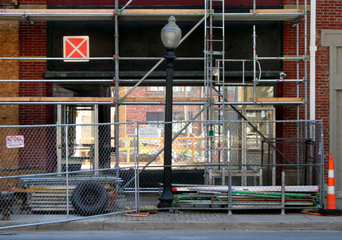
Analysis from the Other Side of the Fence But from the outside the chain-link fencing – and in old mapping – I can still see much. Saturday morning, August 16th, I conducted some ‘visual archaeology’ on the Carlisle-Howson after hearing the the building may have been reduced to nothing but a facade. That’s not what I heard the plans had called for, and it would be far from necessary – I was certain the building was mostly sound even after all its abuse and weathering.

I’ve seen some buildings that were victims of a “facadectomy” – only the historical front elevation was saved, with essentially a new building built behind it. Though that practice retains some of the historical appearance, it’s a bit hypocritical, sometimes wasteful, and usually a bad compromise. Such buildings I’ve witnessed tend to have hokey storefront replacements that belie the lack of understanding of the historical architecture that was saved, with no attempt to mask the concrete block (at worst) and brick veneer (at best) on the other sides. When you walk in, it feels like just a modern building wearing an opera mask. The historical interior brick walls may have been inconvenient and structurally untestable…but Mr. Contractor, how will your new walls fare after a century or two? Two examples I can think of are in downtown Athens and across from the Convention Center in Columbus.
Who, What & When Even as a preservationist, I conduct architectural post-mortems to further understand historical architecture. Fortunately, this is only moderate surgery, not wholesale demolition – but there’s still some interesting details that have not seen daylight for 120 years (1894 Howson Block), 129 years (1885 Carlisle 2), or maybe more than 167 years (pre-1847 John Carlisle Home and earlier). But first, clarifications of the what and when on the site: In Pat Medert’s excellent volumes on the buildings and people of downtown Chillicothe, she records the history here in her Paint Street and Main Street volumes.** She has written that a man named William Wallace (no, not Braveheart!) acquired the corner lot in 1809. He had built a log or wood frame building here by the time he sold it to John Carlisle in 1817. (That building could be considered ‘Carlisle Building No. 0.’) John Carlisle ended up living on the south side of the tract, in a house apparently at about 17-19 South Paint – now the south two storefronts of the current Carlisle. He may have lived there as early as 1822, until his death in 1847. The property measured 99 feet on Paint and 148 feet on Main – the exact land under what is now the Carlisle and Howson buildings, newly recombined. Pat Medert writes that John Carlisle “was one of the town’s most prosperous merchants” after arriving in Chillicothe in 1798 from the north of Ireland via Pennsylvania. But during the economic depression of the 1820s, John retired in 1822 and this property (among many) was foreclosed upon in 1828. The bank eventually sold the property to his son Andrew in 1830. Possibly chafing at the bit to improve his dad’s former location, Andrew built a new two-story brick building at the corner that year, moving his business into it in December of 1830 – this being the ‘Carlisle Building No. 1.’ Andrew may have thus invested in the expansion of commerce already begun with the construction of the Ohio & Erie Canal through Chillicothe. Andrew’s brother Henry Nelson Carlisle joined him in business in 1839, starting a partnership for more than 50 years that ended only with their deaths within six months of each other. They enlarged the building about 1850, adding a third floor – another business investment on the site that may have been timed with another major transportation improvement in the area, the coming of the first railroad. (This could be considered ‘Carlisle Building No. 1.5.’) That is the end result pictured in the only known photo of this first Carlisle Building, probably taken in 1884 – and probably when it became doomed for the second Carlisle Building.

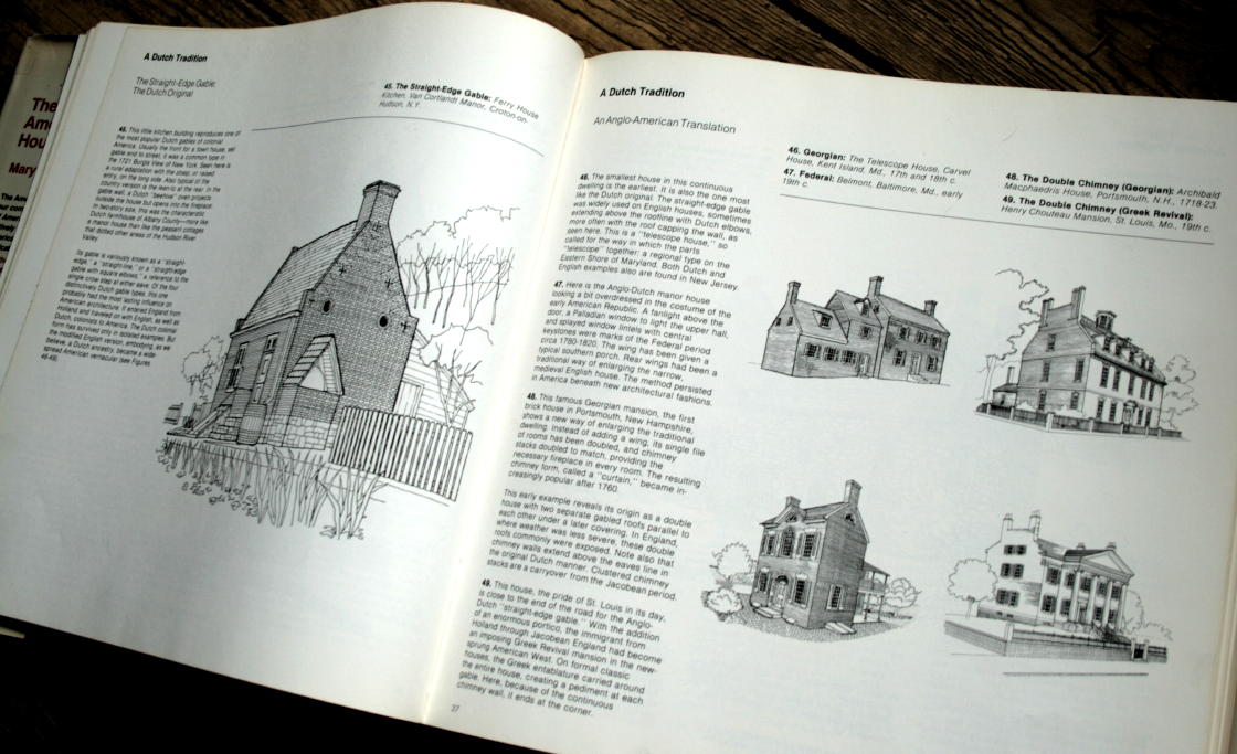
Last Image of a Doomed Predecessor The photo shows a simple, mostly plain building typical of Ohio in the first half of the nineteenth century. Clearer copies of the photo (such as in Pat Mederts books and Images of America: Chillicothe, Ohio) show “patera blocks”*** at the ends of window lintels, popular for both the Federal and early Greek Revival style. A downspout strikes down at the 3/5ths point on the front wall, with a large collection box and wings at the top to help fasten it on. (Similar downspouts are on the David Nickens Heritage Center at 71 West 4th Street – though I think those were saved from another building). Another downspout is on the side (north, Main Street) wall. Under the front and side eaves are friezes, the projecting flat trim. Above them are corbelled brick cornices, where the brick courses in the wall are stepped out as ornament. Then the gable ends have parapets, and massed wall chimneys somewhat similar to those on Adena Mansion. This profile of the parapets could be called “Dutch” (see Mary Mix Foley, The American House (1980) pp. 33-37) – but like other buildings of similar age here in Chillicothe, this may be an architectural choice, and not the result of the contractor’s ancestry. Early commercial buildings such as these were little more than glorified houses (as was most everything else), and if you imagine Carlisle 1 without the added third floor, you can see it was essentially a five-bay side-gabled I House core with a side rear extension (just to get technical…). (…The “I House” is a house type that is one room deep, usually has a center stair hall, with one room to each side of it, and two stories tall. The Lucy Hayes House is a great example of that. (One-story versions are called “Virginia Cottages” in Chillicothe…but that’s another blog. But if the core of the Carlisle 1 was two rooms deep, that’s another matter…) The first floor facade may have been rather houselike originally, with domestic doors and windows instead of storefronts – which may have been remodeled when the third floor was added c1850. The storefront on the right may have been originally a door and window, and the center stair hall opening may have been a door with typical Greek Revival trabeation**** instead of a double door. Also note the shorter two-story commercial building to the right, with three bays of storefronts. That was where John Carlisle lived, earlier. Whether his house was remodeled or replaced into that clumsy agglomeration, all of it was demolished and replaced in 1885 with the south part of the new Carlisle Building. But I get ahead of myself…
Departed Details Documented on Fire Maps I originally thought that the exact location of Carlisle 1 was used for the location of Carlisle 2, and that the smaller commercial building to the right became the Mosher Block at 17-21 South Paint. But upon analysis for this blog, I realize my error – the commercial building to the right was also used up in 1885, and the Mosher Block is beyond the right edge of the photo. This is clear on the earliest available***** Sanborn Fire Insurance map, from 1884. The three images below are my color-coded crops of Sanborns, showing the southeast corner of Paint & Main. (The originals are color-coded for materials, but the digital copies I have are scans of monochromatic microfilm.) Lighter tints indicate one-story parts, and darker indicate two or three stories, as indicated by numbers. An “x” indicates a wooden (shingle) roof, and a circle indicates sheet metal. Stairs are self-explanatory, and major walls and doorways are indicated. An extension of a wall outside the footprint with hash marks indicates a parapet above the roofline. My added red tint indicates the Carlisle building of the time (no. 1.5 or 2). Orange and yellow tinting is for other adjacent buildings, as explained in the captions.

The street addresses have not been standardized yet; either Chillicothe or the Sanborn company uses some sort of odd numerical system. Note the “Shop” at the rear of 820 (labled 820 1/2). The one-bay wide “barber” shop on the east end of the Carlisle will be demolished for the east part of 8 East Main Street. That narrow shop was probably built in a rear passage originally intended to access the back lot of Carlisle 1, but later sacrificed for rental income. An external stairway rises up the north side of the rear extension of the Carlisle, as visible in the photo. Another interior stairway is in the center of the front/west, accessed from the center right door in the photo. The little third floor bit in the center of the building was probably wood frame, added for an extended stairway to the third floor “hall” or meeting room. Note the propensity of barber shops. Remember, they did more than just hair styling – the red of the barber’s pole meant blood, and the white, bandages!

Here, our current Carlsile Building is present, earning an identifying label which most buildings do not garner on Sanborn maps. The Howson is not yet here, though a building has been removed from its future location, leaving its rear outbuilding. Note that the Carlisle houses Herzog & Company’s clothing store in an L-shape around the barber and Howson’s drug store, with E.M. Newman’s millinery & notions where the Harvester Restaurant will be.
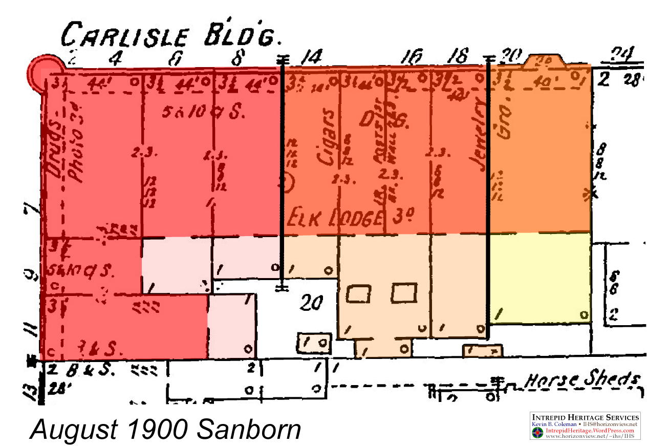
Both Carlisle 2 and the Howson are here! A “5 & 10 c” shop has replaced the clothing store and beyond. Hathaway’s home and photography studio occupy the entire third and at least the east part of the fourth floor. In the Howson, the Elks occupy the third floor. The double shop at 16 East Main has a pair of skylights in the rear. Tinted yellow is the Hellmuth Building, built at the same time and using the same architect and styling as the Howson, but being a separate property then and now. More details on the occupants of the various buildings and shops can be found in Pat Medert’s volumes.**
Unburied!

This appears to be the foundation for the “shop” indicated on the 1884 Sanborn map. This building was clearly demolished when the 1885 Carlisle was built, with part of its foundation reused as part of the foundation for the rear parts of the new building. I doubt there would be any way to find the exact date of this little building, but I’m guessing it could have been a summer kitchen for John Carlisle’s house that was later reused after the house was replaced or remodeled into the commercial building in front. This was probably sometime after John Carlisle’s death in 1847. The clear-cut left corner of the foundation indicates this is the outside of the foundation, where it would have originally turned the corner towards the upper center of the photo – but that part appears to have been cut off; I’m betting there is a ragged edge on the far side of this corner where the rest of the foundation was demolished as unnecessary for reuse and an impediment in the basement. The large block helping to anchor the corner is a nice touch to an otherwise simple wall never intended to be seen again. The east foundation of the “shop” could have also been reused as an exterior foundation under the east wall of a one-story rear part of 6 East Main. If I remember right, this L-shaped foundation would have been under the restrooms of the “Carlisle Corner” L-shaped interior mall, next to the Model A Ford. The only other stone foundation I could see (through the fence) of the 1885 Carlisle is under its east wall (also used as the west wall of the added 1894 Howson Block). All other visible 1885 Carlisle foundation / basement walls appear to be brick. The Howson is different though – large blocks comprise its foundation. (Again, they are sandstone, not limestone!* The decade-later 1894 Howson also differs from the Carlisle in more iron or steel – see the above and below photos of the rear, with contrasting 1885 Carlisle versus 1894 Howson Block…but I get ahead of myself.
Metal Braces Although the 1885 Carlisle shows only masonry on its public facade, there is just a little structural iron or steel inside it, which is to be expected for its age. In building technology, skyscrapers (then still short, only 10-15 stories!) were under development, and the structural use of iron and steel for buildings had been growing for a few decades. Aside from the metal beam bracing the underside of that round turret atop a rectangular building, as I photographed in 2009…

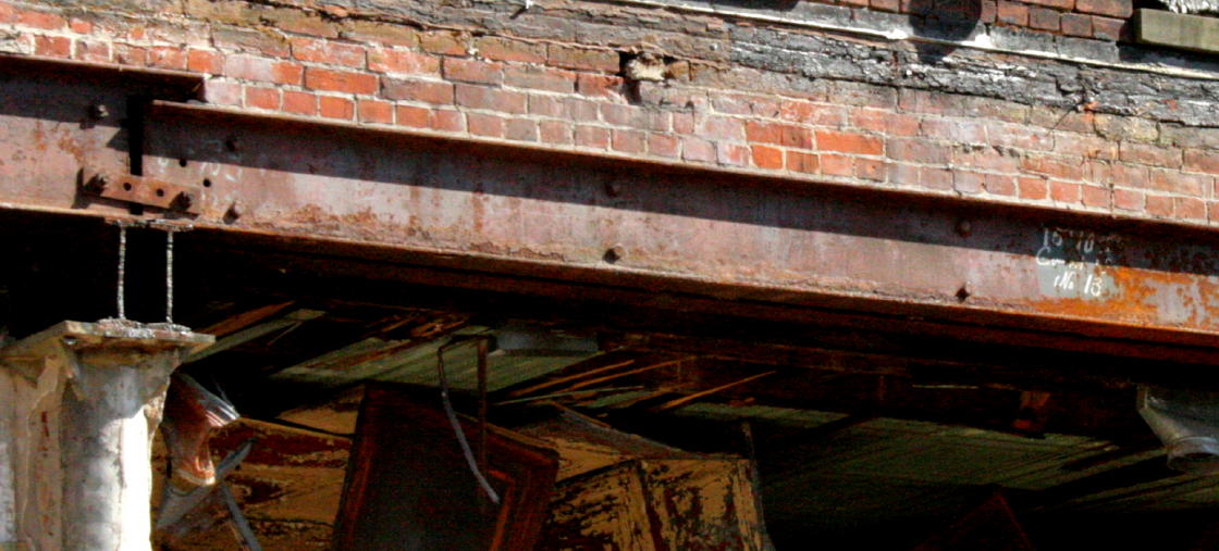
…There are metal beams newly exposed, bridging the rear of the storefronts, as seen above and below. Where the building height changed from 3 1/2 stories to one story, these beams were used to bridge the open commercial space and allow for shops that are deeper than the main building. In other words, the main building is 3 1/2 stories tall; there were rear extensions that projected out the rear that were only one story (as shown on the Sanborn mapping). They were not additions, as it has been repeatedly reported; they were original extensions. Why? Daylight was still at a premium then, even in the age of gaslights. A 3 1/2 story building that filled the entire lot would have left quite a few rooms lacking daylight, many of them becoming un-rentable real estate for offices and apartments. There were also practical and financial reasons to not fill the lot with a huge building…but the end result is the same as on many 19th century commercial buildings in Chillicothe and elsewhere – a tall front with a rear tail. Even the post-fire 1852 and 1853 buildings on the northernmost block of Paint Street are really only two rooms deep at the top, but about twice or thrice that on the first floor. In the Carlisle 2, other beams running along the sides of the rear extensions may have been added, along with concrete rebuilding, when side-by-side shop space was combined. These were also recently cut off along with the walls under them. All this is to allow for rear parking and other modern necessities. (Speaking of which, what do do think the little buildings at the rear of the lots, shown on the Sanborn maps, were for? Hint: I believe sewer service was available starting only about 1890. Note the little buildings behind the post-1890 Howson are smaller…)

In the photo above, on the roof at the right is a furnace chimney for the Howson, which continued down through a circular swelling at the first floor steel pier on the right. (The Carlisle’s furnace chimney was behind the turret, and had been removed below the roof by 2009.)
In the center is the seam between the two buildings. The Howson, on the right, has slightly darker brick and slightly different third floor window placement. The remnant of a rear service stair rises from just inside the left wall of the Howson, between the two new square steel posts. It would have begun at door at the back of the rear extension, which is why what’s left of it is already about five feet above floor level. Above it is a large circular window which probably lit the stairway as well as it could, but has since been bricked up. The builders could have used a square window here, but opted for the elegance of a circular one, even for a rear service stair. (These circular windows and vents were popular in the 1870s-1900s in Chillicothe; can you think of others?) Above that is an extra-tall stairway window, probably for the stairs rising from the front of the building. (No, I’m not sure how the two stairs avoided each other!) To the left, the Carlisle has an incongruous pair of square windows on the third floor, probably an alteration. Above that is the fourth floor added by the previous attempted renovator. In the corner at the left edge, the outside original brick wall has been removed; if I recall correctly, this was where an addition was built for bathrooms in the early 20th century. Such additions tend to be 1) flimsy, 2) wounding to the original building, and 3) eventually leaky and cancerous. (In fact, two ways to slowly destroy a historical building is to add a cheap kitchen or a cheap bathroom to it, especially on the upper floors. Drip…drip…drip…) These would have been located past the top of the Carlisle’s stairs from Main Street.

Above, the “3” may be be either the size of the beam, or an assembly number. The maker’s mark appears to be “JONES & LALCHLINS.” The I-beams may be screwed or bolted into the multiple wooden beams behind them, in the shadows – or they are not I-beams, but two channel beams (a sideways U-shape) bolted together to create I-beams. A newly amputated I-beam extends towards the camera, atop a brick pier with added poured concrete.
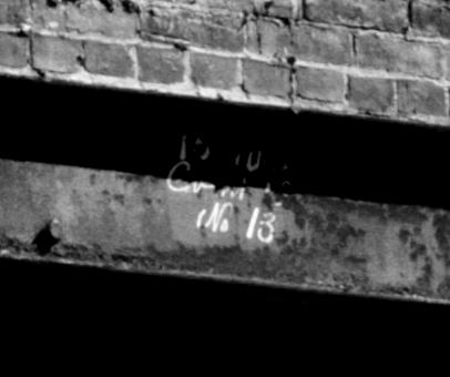
I have photographed similar painted marks on beams taken from the c1890s or 1930s additions to the August Wagner Brewery on East Water Street, demolished about 1988.
Ok, I’ve overwritten as usual, and than had to re-compose graphics to match my re-editing of my overwriting…enough’s enough, let’s get this published before my historical analysis becomes history! I wanted to mention the recurring architect(s) who designed the Carlisle 2 & Howson, show photos of the interior of the tower/turret, a pre-trimming aerial, and other perspectives. But four days after the photo session that inspired this article is a good timeframe to follow. Oh, and I know of a historian who would be happy to provide this kind of visual, photographic, and cartographic overanalysis of YOUR buiding for a reasonable fee. ; ) – finis –
P.S. I hated those red “X” signs when they were put up over the front doors. They implied failure, political antagonism – and possible invitation to further arson – in stating that the building was too unsafe for even firefighters to enter. (They’re even more of an insult on Smith school!) Allow me to offer a free tour in trade for one of those signs. I need some target practice.
Endnotes
* The Gazette also has a video, which can be viewed in their webstory or independently.
However, in the snippets of the tour, I noticed project leader and renovation company owner Michael Chesler misstating two things – minor and technical items that don’t really call into question his knowledge and skill as a successful restorationist / developer / capitalist – but still grating on my knowledge:
1) He says the original foundation is limestone. Why, why do I hear that locally? What is Adena mansion is built of? What was the “first statehouse” (the “Old Stone” Ross County Courthouse) built of? What is the Mary Worthington Macomb House (the old stone house on South Paint) built of? What is the Renick enclosure in Grandview Cemetery built of? What is the gateway to Brewer’s Heights (built from remnants form another early mansion, Duncan McArthur’s mansion “Fruit Hill”) built of? What are most pre-WWI foundations built of? What underlies our flat-topped hills and is easily quarried on their edges? Our locally renowned Waverly Sandstone or Berea Sandstone! NOT LIMESTONE! Argh!!
Columbus uses local whitish limestone often with fossil shells. We have sandstone, a warm-tinted hard but easily worked rock formed of ancient seaside sand with iron compounds. …But that’s another blog!
2) He says the water line that leaked a huge amount after the fire had easily drained into the excellent soil where the glacier had left silt, preventing foundation failure. Technically, soil is only the top layer of earth, usually only a few inches. Beneath that is subsoil, where clay tends to filter down over millennia. But beneath that is “parent material,” the largely unaltered foundation of the ground.
On our bedrock hills, it’s stone; in our floodplains, usually river silt. On the broad terraces such as downtown Chillicothe is built on, it’s glacial outwash. The glaciers did not directly create the terraces – their meltwater did. As the 1,000 foot-thick layer of ice retreated, the rocks it had ground-up while advancing were washed out. From fine clay to boulders, water flushed and sorted the material, choking the waterways that were re-forming in our valleys.
Where Chillicothe is, the Scioto was not a single large stream bed, but a multitude of small streams spreading and weaving across a level bed filling the entire valley. They created the almost level plain of silt, sand and gravel underlying farm and town. Dust storms coated it with silt and clay about three to four feet thick that developed into the soil proper, but underneath that is the parent material of river bed sediments – a very porous medium that allowed millions of gallons of city water to drain away in 2003 without causing too much settlement under the Carlisle’s foundation. (About 200 feet of the sediment filling an ancient bedrock valley also acts as a geologic sponge, holding groundwater that can be pumped up for drinking and industrial uses.)…But that’s another blog!
** Paint Street pp. 102-107, notes 24, 155-162; and Main Street pp. 50-59, notes 51, 66-89
*** “Patera” is the Latin name for a classical ritual saucer or flattish bowl with a rasied button in the center. Its sculptural image was also used as carved or molded architectural ornament in classical times, which was revived in the 18th century and continued into the 19th – often for the end blocks of door and window mouldings and lintels. Three good examples of these are at 29 East 5th, 46 West 4th, and 264 North High. (Please respect private property and residents’ privacy!) The Lucy Hayes House also features them in the interior door and window frames.
**** Trabeation mens ‘post-and-lintel’ structure. In the case of the typical Greek Revival front doorway, that means a door flanked by narrow sidelight windows and topped with a transom window, all in a simple upright & vertical construction. Again, the Lucy Hayes House (and many other of the Canal Era) are excellent examples.
***** I have downloaded Sanborn Fire Insurance maps from 1884 through 1925+, but there is also an August 1879 issue that I can find only at the Ross County Historical Society. It’s not quite as available as the digital copies I have in my computer.
IHS • KBC • AD MMXIV AVGUSTUS XX

Interesting.
On Sat, Aug 16, 2014 at 3:58 PM, “Intrepid Heritage Services • Kevin B.
LikeLike
Finally! Finally! Done and done. In record time. ; ) Comments, corrections anyone?
LikeLike
Kevin – I know the Carlisle Building was built by the Carlisle family. Was the Howson building built by Arthur Bagshaw Howson who was married to Margaret Carlisle?
LikeLike
Actually, the Carlisle was built by the Howson family, but named after their in-laws. The brothers Carlisle operated in the first “Carlisle Building,” but died in 1878 and 1879.
The husband of sister Elizabeth Carlisle, Arthur Howson, had the current building built in 1885. The same family had the addition on Main Street built ten years later, and this time named it after themselves.
You can read more in my source, Pat Medert’s Paint Street and Main Street volumes. And sorry for my delay – either WordPress did not notify me of comments, of I overlooked it.
LikeLike
Oops, just saw a few typos and corrected them. (Please let me know if you see any!)
So much for finishing a blog “in record time” – haste makes waste…
LikeLike